
[Original Draft 2022-03-11]
Rewind back to the 8th...
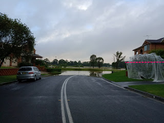
7pm or there abouts and looking down toward the 'problem end'. The water has reached the road gutter in front of our place.


Skip ahead 2022-03-09 (next day)...
At around 1:30am I woke, really didn't feel like moving but I hauled my ass of the couch. Looked through the window in the darkness and saw that the road in front of the house was just reflecting silver. The road was now covered. So this, but dark.

I grabbed my keys and moved the car up from the road onto the driveway. The prior evening had still been humid enough, but out there in the dark is was cold. The water was cold, the air was cold.
I normally leave the car on the road as the driveway has an angle to it and a mechanic has told me that parking on a weird angle can make the computers miscalculate when it starts up... or something.


This was (thankfully, and more or less) the highest that the water rose. It might have gone a tiny bit higher between 8-11am but it was pretty much down from there. We were marking the driveways with rocks to check. High science.
As well as the temperature change, the sky was notably 'lighter' (cloud cover) and it just didn't 'feel like rain'.
Just a side note: the safe end... with the water at this height it was possible to drive through to dry road. The dry road started just around the corner (out of sight of these pics) and many people had parked around there just to avoid this issue. The main concern driving through the water at this level was spreading a wake onto the property yards and up onto houses. The water came up to roughly 'mid-tyre' so it wasn't reaching the bottom of the door on 'modern utes'.
The street entrance was choked with cloying water weed and it had floated down that street (we're perpendicular and it doesn't come up our way) pushed by tide and wind.
it was a toss up whether to park around the corner or stay. And at my place there was another meter of dry before it reached the top of the drive/garage. We really are (again, thankfully) at the high point of the street, road and terrain. The water would have been half way up the bottom storey of the house before it got to the car engine. A gamble, but a safe (enough) one.
An aside: many people chose to stay and wait it out. Most families with kids shipped them off but by majority all the houses around me had people waiting it out. Just seemed the thing to do.
Even if we had to retreat up on the top storey, water getting up to that level would have been proverbially biblical. Again, a relatively safe gamble against that happening. And being transient, especially with pets, carries its own complications.
Checking things out...
Feeling hopefully that we'd seen the worst of it, we were collectively a little happier once light arrived.
I took out a kayak and checked out the 'safe end' first, this was before someone actually drove out for smokes or whatever. Was about the height of a kayak oar at the deepest. And the road has a substantial hump in the middle, so just avoid the curb.
I made two little kayaking expeditions out.
Recalling this pic from the prior days, the water was up to approximately the dotted line on the tree (right side of pic).
I was cautious for snakes and other critters but there were mainly just insects and birds on top of the vegetation.
It was a slow crawl through the stuff but I have many hours on a kayak and it was just a matter of adjust and persevere. Felt like running through water but wasn't excessively draining.


This is looking directly out just after the water weed. It doesn't look like much here but on a small boat such an atypical body of water feels unsettling.


This is the street corner in regular times. The dotted line is approximately the water height here.
To the right of centre there are a couple of speed signs a little ways down the road (also with dotted lines) and these were just poking out of the water.

Btw, the road is just a 90o corner, this shows it "panorama'd".
So I paddled all the way down the 'edge road' of the suburb. Another street sign for reference - note this one for the final picture in this article.


The road in this picture goes down to a flat 'carpark' area that extends to the bmx track. Change rooms on the right obviously (approx water level marked).


Ok, logically 1/2 way up the bmx canopy is the same as the water level on the changeroom. So there you go.
Credentials: When I was growing up we had floods in our area (coastal). Our house wasn't in danger and there were lots of swamps around next to the major river in the area. I took a surf ski out onto the swamps then with a mate - a couple of times I think. So I've been doing this for a long time (30+ years) and if I felt it was too dangerous I wouldn't have gone.
As for anyone bleating about having to rescue me and endangering official resources; No thanks I don't want or need your rescue and intrusion - I know my capabilities, you don't - so mind your own damn business.
I didn't see any snakes during my two outings. If I did I would have been the fastest boat ever recorded in the suburb. Someone mentioned to me that they had been out during last year's flood event and had seen several... brrrrrrr.
On my second trip out, closer to 10am I guess, the wind had picked up substantially coming from the south-east across the lake toward the suburb. There was a lot of chop and tiny whitecaps. It wasn't particularly rough, and didn't even impede speed noticeably, just noisier and more spray.
Btw, I wasn't the only person out there as well.
And closing off...
Think I had a nap once I was done with that. I popped out again around 2pm and the water had receded a bit. Scientifically proving we're at the highest point in the street, the return of this little island was a welcome sight. At its highest the water was about 4-6 inches over this point - still wadable with gumboots.


2022-03-10
730am and the only sign of the event is a bit of mud and some pooling at the drain. The 'danger end' still has some water about 3 houses from the final corner, and some at the culdesac.

I went for a drive around 9am finding somewhere with power so I could work. Was able to get to Windsor over big overpass with only small detours around and the 'wet points' were now just mud puddles. Then all the way to Rouse Hill and while there was water in the creeks the drive was unhindered.
I noticed one of the emergency signs saying 'avoid emergency at mcgraths hill' (paraphrase) for traffic pointing away from there anyway [shakes head], and now with the water well on its way down (i.e. reporting after the fact). Whomever is in charge... really needs to not be - this place is run by imbeciles.
Last years event seemed to really drag on and on, but perhaps that was due to it being such an unknown, and we also had a long build up to 'the rise' this time around. Fortunately 'the fall' was extremely rapid too.
Anyway, we went for a walk, noticing some large graders clearing up at the end of our road. And then found people piling up the water weed on the next road. Some air force personnel and equipment was in the area helping too; thank you.

And finally, this is the road I showed earlier. 24 hours before the dotted line was the street sign (just over head height), and you can just see a faint water line on the fence (which I rested against when I took the earlier photo).
Where I'm taking this photo from I would have been about chest high in water, now just muddy puddles.

2022-03-11
We haven't had anymore rain, which is pleasing though there's plenty of cloud around. The weather report suggests showers between midday and in the evening but who knows. Regardless it's obviously not just the rain falling here that causes the problem, seeing it makes it feel worse.
I haven't been out since that last walk and am hoping the water continues to dropping on the fields. Again, I'm kind of over it all and hoping that that's all we see of floods for the year. And if I can put my order in now, we can do without a repeat next year please.
As I mentioned earlier the water reached, 'just up to that point' for many houses where it was almost at the front door. There were also houses not so lucky that did get water on the ground floor. More so than last year.
Unlike the media's braying implications, we were not all washed away. There was damage, but I think the majority of those with water on the street probably came through relatively unscathed, and a good 6/7th of the suburb was entirely unaffected.
As it was last year, it ended up being something of a bonding experience for those remaining, so something positive to be spun from it I guess.
And thank you to those people thinking of us. Sorry, the media scared you... again.
Okay...
We just went for a brief walk down the road. The low corner is being hosed off by a mix of cleaners, firemen and air force. Slimy, muddy, a bit of cow manure thrown into the mix. Smells of the sea, but inland. Over all effect = not that great.
Lots of sandbags on the curb presumably awaiting pick up. A number of houses with piles of water affected stuff awaiting the garbage truck. Overheard that the 'worst corner' (the water weed area) just got power back a couple of hours ago. Which confirms that our circuit and theirs are separate.
Walked just to the corner (the panorama one) and this is the view over to the fields. The water is two metres down from the road. So we're back to having a little safety buffer there.

And that will do for part 2. Hopefully there will not be a part 3. Or a repeat next year, fingers crossed.
Until next time (with something not flood related)...
No comments:
Post a Comment